The Solomon Islands Postal Corporation is undertaking a large challenging project. They are embarking on mapping and developing a National Address database for the country.
This is a large-scale geospatial project, even for a country of only 700,000 people.
There are many challenges in developing such a system, but having the support of an adaptive GIS online solution makes it much easier.
The Solomon Islands
The Solomon Islands are located in Oceania, northeast of Australia and east of Papua New Guinea. The country comprises 6 major islands and nearly 1 thousand small islands.
Most of the population lives in rural areas across the larger 6 islands. The capital city, Honiara, is also the nation’s largest city, with a population of almost 100,00 people.
Efforts to grow the small nation’s economy and tourism industry are underway.
Many companies like the Solomon Islands Postal Corporation are investing in new technology like fintech, EziPei, and expanding the reach of global e-commerce.
Solomon Islands Postal Corporation
The Solomon Islands Postal Corporation provides three major services: delivering packages, retail postal office services, and fintech, which uses wireless money transfers.
The company is improving the postal delivery network to ensure any purchases from the United States and beyond can be delivered to the correct location on the islands.
They are in the process of developing the first-ever postal code for the Solomon Islands. The team is looking to GIS and an online GIS solution like GIS Cloud to collect, organize, manage, and deliver that data to clients and decision-makers.
Project Challenges
The project challenges begin immediately from the project start. With such a large-scale project, investing in new technology-based services requires planning for the financial investment.
Having access to transparent pricing is important. Knowing your costs from the beginning allows you to plan with accurate numbers and budget as needed for the project.
With the finances organized, the next step and challenge are identifying the key information that needs to be collected from the field. Working with a GIS Cloud solutions consultant, Solomon Islands Postal Corp has been able to develop a customized Mobile Data Collection form.
The form captures extensive address information of buildings and residences.
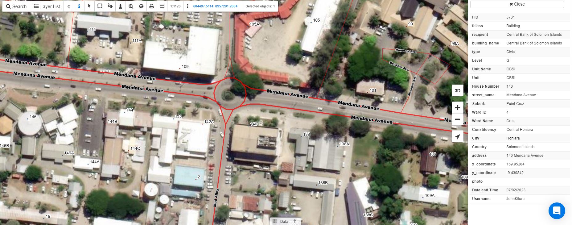
The Solomon Islands project team expressed the need for aerial imagery as a basemap in their maps and data portals. An up-to-date aerial image gives viewers a sense of familiarity with where they are in the world.
All this data must come together into a centralized data portal for decision-makers. The end result will need to be an easy-to-use portal for non-GIS users to make decisions based on the data presented.
The ultimate goal of this project is to provide excellent customer service to their clients.
By investing in developing an accurate National Address Database, the Solomon Islands Postal Corp has taken a leap in delivering even more reliable services to their clients. GIS Cloud has been there as they have faced these challenges and will continue to do so.
Project Pricing
Communication is important in every partnership. We at GIS Cloud believe strongly in that.
Budgeting for a project like this can be difficult. The number of licenses may change as the project changes over time and more people join the effort.
Pricing should be out in the open and easy for our customers and potential customers to see and calculate.
No need to “Contact Sales for Pricing”.
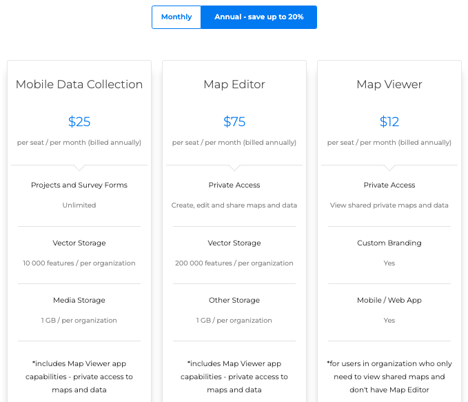
The Solomon Islands team is in the early stages of launching their effort, but having confidence in their costs makes moving forward easier for the project lead and their budget.
By taking advantage of our free 14-day trial, the project team can understand what they will need regarding personnel and hardware for data collection.
Field Data Collection
The initial creation of the dataset is important in building a solid and reliable foundation that supports the project’s growth.
The Solomon Island Postal Corporation signed up for a free 14-day trial a while back. While working with one of our solution consultants, Domagoj, they created a custom form for the Mobile Data Collection application. By investing time and energy in developing a comprehensive data collection form from the beginning, the returns will be immeasurable.
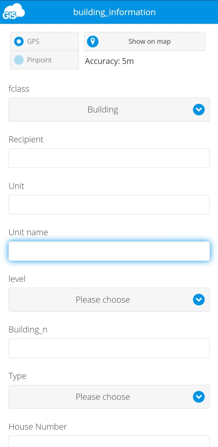
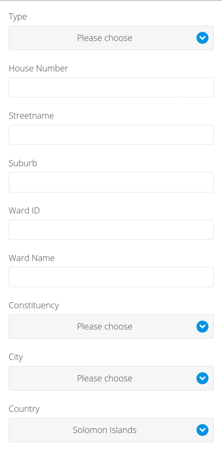
Collecting an extensive amount of field data on buildings and address locations will pay off down the road. This massive effort will prevent second or third field data collection efforts in the near future.
Customizing the data form allows the team to collect unique data to create the National Address Database. The field survey will capture fields like Ward ID, Ward Name, and Suburb.
This on-the-ground data collection will create accurate and authentic boundaries of the areas.
Aerial Imagery
Maps with imagery are calming and bring immediate familiarity to an otherwise confusing environment. They help the viewer get oriented right away with easy-to-identify landmarks.
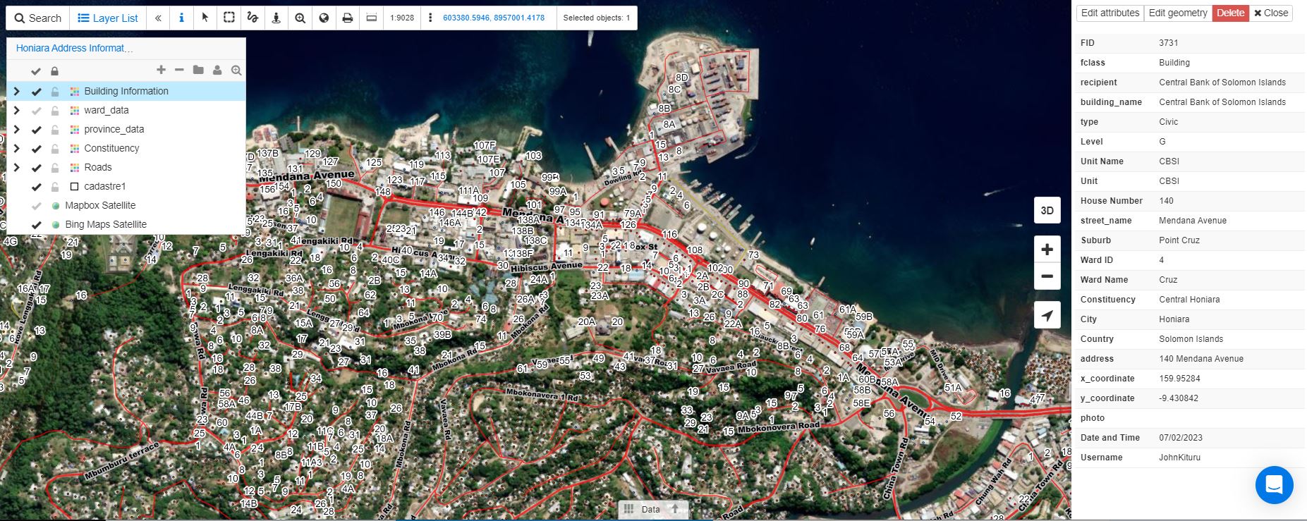
In Map Editor, under Tile Map Services, there are a number of different base map options. You can add street graphic-themed base maps or the latest satellite imagery from Bing or Mapbox.
These base maps will be used in the Map Viewer, as well as the Map Portal and Mobile Data Collection app.
Geocoding Addresses
Once the road network of the Solomon Islands has been created, the process of geocoding addresses can begin.
Using GIS Cloud’s Gecoder, you can map address locations. Your addresses in a table can be accurately mapped in just a few steps.
First, organize your data into columns before exporting it as an XLS (1997-2003) or CSV file.
Next, drag the XLS or CSV file into GIS Cloud’s File Manager. Set the address values to the correct corresponding column in the table and then run the geocoder tool.
The data will be mapped for you. You can export the layer as a shapefile, CSV, KML, or MapInfo file.
The data layer can be pulled into the Map Editor for further analysis.
Data Portal
Bringing together GIS data for use by others is where GIS and good data shines.
Once the Solomon Islands Postal Corporation has collected and mapped their data, they will create a customized Map Portal.
In the Map Portal, once Solomon Islands Postal Corp has finalized their field data and performed the necessary QA/QC, the data will be published and available to the public.
The Map Portal can also include the geocoded address as a layer.
The team will also be able to create regional boundaries from the Ward and Suburb information they collect. Boundaries can be shared with a few clicks to other industries and public organizations for collaboration.
Customer Service
The goal of Solomon Postal is to provide excellent service to their clients. They are set on achieving this goal by committing to collecting accurate data and sharing it with their clients.
By sharing data with others, the data can be improved from feedback received from the public. Delivery services will become predictable and improve delivery efficiency.
Just like Amazon and others, the Postal Corporation will be capable of providing faster deliveries to the right locations across all the islands.
Conclusion
While this blog post concludes here, Solomon Islands Postal Corporation’s journey is just beginning. The team is currently collecting field data and preparing to develop a customized Map Portal.
Our free 14-day trial was the jumpstart the Solomon Islands company needed to improve and grow their business operations.
Our solution consultants are available to demonstrate how your project could benefit from using GIS Cloud. Sign up for our free trial, and we will reach out to you and your team.


