AI-native GIS. Just ask.
GIS Cloud AI turns a sentence into action. Capture in the field, build and fill forms, build maps, run analysis, create apps and reports. You review and confirm, it builds. ISO 27001 certified.
No credit card required · Works with your existing GIS Cloud data
Conversational GIS AI helps you understand your data. Generative GIS builds with it. You confirm every output suggestion before it's built.
Powered by GIS Cloud AI
Four ways AI works inside GIS Cloud
Every AI feature proposes; you confirm. You stay in control of your data and your maps.
Ask AI
Generate maps, layers, forms, classifications and analysis in plain language.
Build entire data collection projects, with a custom survey form connected to a map and a mobile app in minutes.
AI Form Fill
Turn what you see or say into structured records, with a confidence level on each value.
AI improves suggestions for your form fields with each new photo or voice record.
AI App Builder
Generate apps and dashboards, including branded PDF reports, then refine by chatting. No code.
Apps are by default private, but you can make them public.
MCP Integration
Connect clients like Claude or ChatGPT to your account and do any kind of job with your data (create maps, analyze data, generate reports..). You control access.
50+ tools available to work with GIS Cloud and connect to other apps.
Trusted by organizations around the globe


Loved by mapping teams
What people are saying
"The AI selection tools are brilliant. It saved me having to use desktop GIS. For one selection, manually it would have taken an hour, AI did it in less than a minute. Very impressive."

"The easiest GIS platform to get started with, so flexible. The Map Editor acts as a browser-based, full-featured GIS interface with transparent pricing, security compliance and easier customization."

"The AI returns the distance matrix results. It’s really impressive. Now, this tool makes it easier to perform services; it reduces the need for extensive personnel by automating routine tasks."

"We are solving the problem of field data collection with GIS Cloud MDC. We enjoy the benefit of using an all-in-one solution for our field data collection activities including assets mapping and customer Enumeration.
No complexity at all: one product for field data collection, field activity monitoring, visualization, and seamless data sharing."

"I have been using the AI Assistant, and I am generally very pleased. This is a completely new way of developing and configuring systems!
But even more exciting is the use of AI to interact with the GIS Cloud system as a user."

"GIS Cloud AI turns data into meaning. With its help, I become THE tool for very specific answers and comparing data. Another benefit is the classification and styling of features and attributes; AI serves as a companion and helps to straighten the process. Overall, GIS Cloud AI is a major step in the easy use of GIS collection and evaluation."

"I recommend everyone to try GIS Cloud if you're looking for a replacement for ArcGIS or QGIS. A perfect bridge between the learning needs of my students and a mature market solution and service."

"We don't even know how we managed to do our business without GIS Cloud. They helped us define the processes and educate our crew about the workflows."

"Mobile Data Collection has changed my entire work process. The ease of use, and the power of real-time results, even off the cell or internet networks, is so powerful. The ROI more than pays for itself."

Online GIS for managing operations
One platform, the whole job
Capture data on-site, online or offline, and watch it flow to the map your team is already working on. Analyze it, share it, embed it. Real-time, both directions.
Also works on-premises behind a firewall installation.
Field data collection
Fill in custom survey forms (created manually or by AI) in Mobile Data Collection to capture data location with GPS automatically, or use a pinpoint tool to add points and draw lines.
Offline collections are stored on your phone and synced when online.
Data and team management
Review collected data in real time and monitor project progress. AI summarizes changes, classifies, and analyzes data to suggest actions.
Manage teams and jobs, assign tasks, and make informed decisions on the go.
Map editing and sharing
Stakeholders can access your project privately through a simple Map Viewer interface.
To share data and maps with the public, convert your project into a branded Map Portal, or build your own app with dashboards and charts, using AI.
Recent from GIS Cloud
View all posts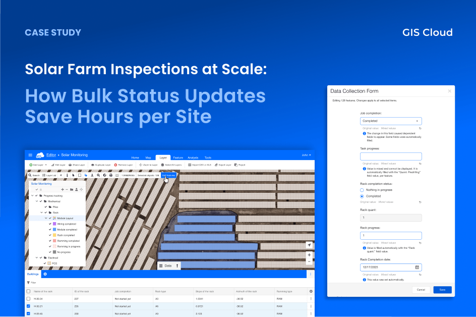
Solar Farm Inspections at Scale: How Bulk Status Updates Save Hours per Site
After every construction phase, inspectors needed to mark dozens of solar panel racks as “Completed”, one feature at a time. Each update triggered automations that calculated progress and…
Read more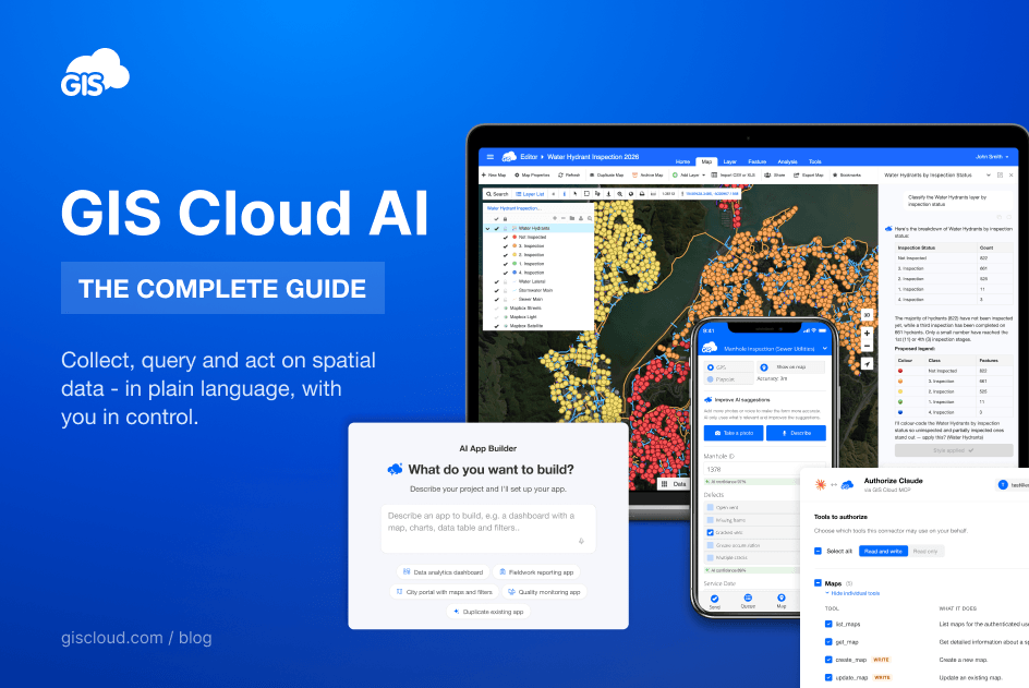
GIS Cloud AI: The Complete Guide
What is GIS Cloud AI? GIS Cloud AI is a set of artificial-intelligence capabilities built into the GIS Cloud platform that let you collect, query, and act on…
Read more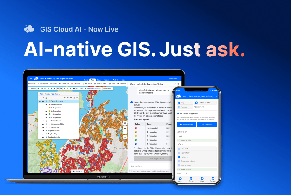
GIS Cloud AI is live: ask your data, fill forms from a photo, build apps from a sentence
For years, AI in geospatial mostly meant computer vision: object detection, land-use classification, pulling insight out of satellite imagery. Useful, but narrow, and almost always the domain of…
Read moreYour next project is one
sentence away
Start free and build your first AI-powered map, app or field form today. No credit card, no setup.