

Nonprofits and NGOs face many common challenges when trying to promote and achieve sustainability, equality or develop smart solutions for various causes. For example, finding funds for an ambitious project can be demanding, never mind living up to donors’ expectations, or getting the word out about the awesome projects you’ve been working on. Connecting with the community is another challenge, along with coordinating own team efforts.
If you work for a nonprofit or a non-governmental organization, there’s a good chance that you’ve encountered some of these challenges yourself.
Knowing all this, now imagine there is a solution that can help you to raise awareness of your project, attract donors, increase your effectiveness, and give you a single way to deliver results in a visually appealing way.
Online mapping software like GIS Cloud can help alleviate and address many of these challenges. Some of them we’ve covered in our Crowdsourcing for NGOs and Nonprofits: Webinar you can watch here.
Technology is rapidly impacting the nonprofit world in great ways. What used to take hours, days, and weeks, or months, to share data through handwritten forms, then transferring them to Excel worksheets, now can all be shared in real time using GIS technology. The power of this technology is radically transforming the efficiency by which non profits can deliver life changing interventions around the world.
– Darrel Larson, Give Clean Water Initiative and The Last Well
No matter if you are doing a nature or heritage conservation project, helping homeless people and vulnerable social groups, working in health and disease control, emergency relief, environmental preservation or want to raise awareness about an issue, the work can be much easier if maps guide your efforts.
So, what are the ways you can use online maps to improve your NGO or NPO project?
1. Increasing Awareness and Attracting Sponsors
If an image is worth a thousand words, a map is worth a thousand more. If your efforts are scattered around the world, working on various locations and projects, there is no better visualization tool than a map to effortlessly showcase what has been done, or will be done. For example, a map can show all the locations of environmental cleanup events, places to sign petitions, protected habitats, illegal landfills, emergency centers and anything else that comes to mind, to deliver the information in the best possible way, directly to your audience.
Scenario 1: Create an interactive and fully branded Map Portal which can be set up in less than half an hour. The Map Portal can have its domain, and you can use it to effectively deliver a message across various platforms (for example, you can embed it on different sites and landing pages).
Scenario 2: Launch a Crowdsourcing campaign where you can get donors around the world to pledge for your cause. One great example is this Dance of Kindness Crowdsourcing Portal.
2. Delivering Results to the Public and Sponsors
For NGOs and nonprofit organizations, retaining funds and reporting to sponsors is almost as crucial as getting the funding in the first place. People and organizations that have invested in your project or cause need to have a clear and unambiguous overview of how their money has been spent.
Scenario 1: Showcase your work on an Interactive Map Portal. For example, if you pledged to plant or protect a certain number of trees in an area, a public map portal is a great way to show what has been done and also what your plans and estimations for the next stages of the projects are.
Scenario 2: If your data is sensitive or you want to address specific people or organizations, you can fully control what you want to deliver and to whom via the Map Viewer application for private access to your maps and projects.
3. Microvolunteering, Building Networks, Engaging Citizens and Local Communities in your Initiatives

Scenario 1: If you are doing a project where you count on high community engagement in to reach your goals, look for the Crowdsourcing solution to help you out. You can engage your network in microvolunteering, sharing knowledge, voting on particular improvements in your neighborhood, etc., or give your supporters a perfect platform to share their achievements and inspire others.
Scenario 2: If you are doing a project that requires individual action taking place at a particular location, and you want to be in control of the data collection process, you can use Mobile Data Collection to gather real-time data from volunteers or staff in the field. It is a great way to engage your network in initiatives such as local cleanup events, interviewing citizens or collecting data about households, etc. One such example is the GeoAid project shown on the map above, in which data about services for socially vulnerable groups were mapped.
4. Better Team Coordination and More Effective Fieldwork
Scenario 1: If your organization does a lot of fieldwork, like Engineers without Borders, or the Give Clean Water Initiative, you can organize your entire workflow around maps – from collecting data (even offline) with Mobile Data Collection, to sharing priorities to people directly on the field. For example, if you work in an emergency relief situation, you can use your smartphone to fill in data about resources needed in a particular shelter or facility, and it will be shown on a map in real-time. It can be used to coordinate your team better and also to communicate data to team coordinators at other locations. They, in turn, can gain immediate insight into where to send people in need of shelter, just by looking at a map.
Scenario 2: Use the field data you collected to notify stakeholders in different agencies and organizations directly. It can help you coordinate and be more effective not just within your organization, but also on a larger scale with other stakeholders.

5. Better Governance: Decision Making Based on Real-time Data
Scenario 1: Once you collect data in the field, either via Mobile Data Collection or Crowdsourcing, you can further use and analyze data to make decisions. For example, based on a particular type of data you collected (e.g., number of hospitals in an area that is affected by the disease), you can do a heatmap analysis in Map Editor to determine what areas don’t have a facility nearby or where you can put a field hospital in case of emergency. It is also a good way to prioritize tasks for your field crew even when they are collecting data.
Scenario 2: You can filter data about work that needs to be done and do custom reports which can be shared with field coordinators via Map Viewer. They can then determine directly in the field where to send their field crew next, without having to inspect the situation themselves, saving time and energy for remote teams.
These are just some of the examples of how mapping software can be of help to NGOs and nonprofit organizations.
We are always eager to support great initiatives and projects, such as those we support each year during the GIS Day Contest. If you have an idea on how to utilize cloud mapping for your organization, let us know.
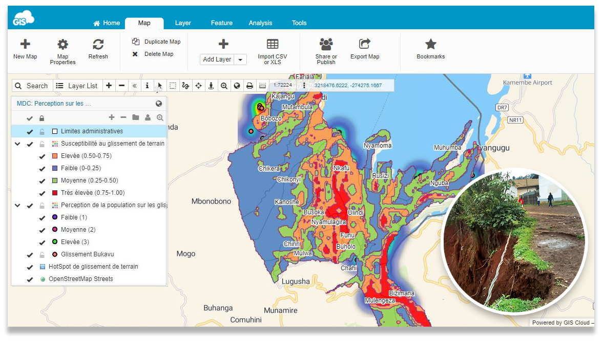
6. Predicting Environmental Risks with GIS tools
Scenario 1: Choosing the right solution to achieve project goals is really important. BEGE-RDC an NGO from DR Kongo recognized the importance of GIS tools to predict environmental risks. In this case, they made a map of susceptibility and a heatmap of landslides in the South Kivu region. Between 2010 and 2015, landslides caused the death of 134 people, destruction of 700 homes and 4 schools in that region. They made a landslide survey that helped them get the necessary information on the frequency of the landslides in that area and establish a Risk Perception Index. This made possible to spatially present the level of perceptions of the respondents in relations to landslides on a map.
Scenario 2: If your project is looking for volunteers who are constantly interchanging in the field, with our Mobile Data Collection you don’t need to worry. Replacing paper and reducing costs, with the use of smartphones, can help you collect more accurate and accessible data in the field.
7. Open Source Software Integration with GIS Cloud
Scenario 1: Different categorical data (hydrological, topographic, human activities, etc.) that volunteers collect and prepare subsequently can be a problem when integrating within different software solutions. Different data can be processed in open source software such as:
- R software – open source for creating a wide variety of statistical (linear and nonlinear modelling, classical statistical tests, time-series analysis, classification, clustering, …) and graphical techniques, and is highly extensible.
- QGIS – open source software where you can process raster and vector data to get a better picture of spatial data that is actually the key of GIS software.
Scenario 2: Now, with the help of the GIS Cloud Publisher for QGIS and Publisher for ArcMap, you can present and analyze all the collected spatial data with just one click in Map Editor application. In this case, GIS Cloud helps optimize, integrate and visualise your data with just one click on your computer. This helps to easier communicate important information to people, helping them understand and perceive what is happening around them.
![]()
These are just some of the examples of how mapping software can be of help to NGOs and nonprofit organizations.
We are always eager to support great initiatives and projects, such as those we support each year during the GIS Day Contest.
If you have an idea on how to utilize cloud mapping for your organization, let us know.